
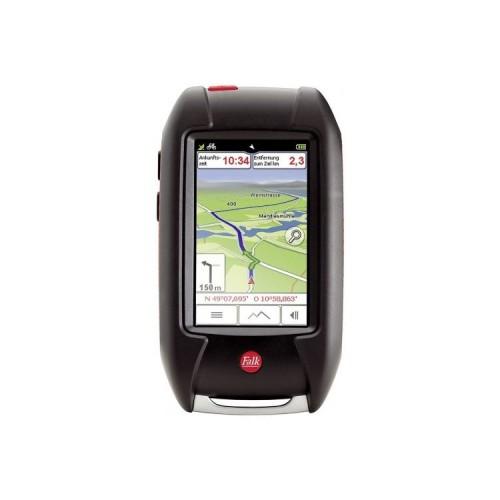
After several hours of training on the device, with the help of the manual available on the home page, I had to review the extent that I could make a full-day testing terrain on foot with the device.
From my findings:
- GPS reception is very good and so well that led me to approach the unit, for example at intersections on two feet just to the branching path. This device also noticed quickly when time has passed on a Abweigung.
- The use of paths in a planned route in the route optimization is, however, associated with surprises. Since paths are used in the forest, which were no longer kept for years or decades. The route will run across country. I had a spot in the woods, as I should have a slope of about 100% slope going down, and at the site were not even see a hint of a path. However, one can be guided very precisely with the Lux 32 through the underbrush and then meets again away on a.
- The representation of the way, that is, whether secured or unsecured, or only one path, the map can not rely on. There were often paved paths shown in the map, then where unpaved roads or even footpaths were found. Of the paper maps that know exactly the other way around. There unpaved roads are often drawn, which are fixed in reality.
- The planning of routes on the device is not well solved: There are to create a route the way through destination entry or Tour Planner, which I have not yet understood why there are two possibilities, since both the flow / structure are very änlich. However, there are two crucial differences: When using the destination input I have the "Route drag" immediately available, only if I have entered a stopover or next destination in Tour Planner. If I take the tour planner I can save my route, which is not possible in turn to the destination entry. However, it is not in the manual how to save a tour. The memory function is "add destination" in the Tour Planner below and then press the OK / button hook hidden. What a bullshit !!!
- Another way to create a tour is tapping the target ind the map in the navigation tree. This opens a menu. But here can not be saved.
- To highlight a destination on the map is possible only with a pen or matchstick.
- The screen responds well to the tapping and dragging. One must not be too fast just because the device is sometimes still busy with the last entry.
- The supplied more new NMH batteries had loud display after seven hours with 50% screen illuminance 20%.
After around 70km experience walking still following:
- The included premium outdoor map is not very suitable, since it does not reflect the reality of the planning. Far too many ways are like written above represented as paved paths.
-In Forest tours lead times by's undergrowth or sections with fifty years of existence without even begin a road or path can be seen. Andererseit the unit repeatedly called on in places to turn to who lack any other way or path.
- In order to avoid that is sent through the thicket, one can not choose the shortest route in the tour options.
- The display lighting is a real energy hogs, however, to get in the sunshine can not do without 100% illuminance. Then the battery has been empty after about four hours.
- An automatic query whether you want to save a scheduled tour, there's only when you have entered at least one more goal for the Tour.
- For hikers it would be beneficial if roads would be avoided. Although this is not always possible, but I had the case that the route should lead across a street, although only slightly longer path led to the same destination through forests and fields.
My conclusion so far: for this price range is not good enough. The software developers should consider from the perspective of the user (lay) their concoction more. Outdoor card and battery performance improvement. Navigation good. The clarity and detail of a (paper) card can not replace the device.


![Project CARS - [Playstation 4] (Video Game)](https://img.tgreer.com/thumb/85x85/f/53/f53c71c7a5bcef5afbcf5ade66e8928a.jpg)


