Positive
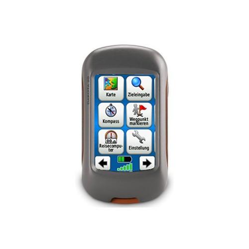
The bad reviews due to the installed maps are not justified for me because the device comes standard with a kind floor plan map of the world that you then have to replace it with a Garmin purchase card or a free OSM map.
As the work with Basecamp (Free program for route planning by Garmin) and the installation of OSM I could learn very well function maps thanks to the Youtube videos of Kai Sackmann.
I've been using it now for all outdoor activities.
When Dakota 20 a much better algorithm has been used in relation to the car navigation devices from Garmin.
By adjustable routes itself between the navigation on foot differed to my surprise (with stairs) and cycle paths depending on the map material used.
Switching between air lines and Wegenavigaion are possible without re-entering the target coordinates.
In the bike navigation on approaching bends is alerted by a Pipsen. This is especially beneficial when operating the display in sleep mode. A quick tap is then sufficient to get back to see the aktelle position. It differs from the track, the navigation will be automatically corrected and displayed by beeping 2 times.
The real fun starts when this function leaves a Mulicache by bike.
GPS accuracy and strength are very good.
The display easily readable in bright sunlight. And even in heavy rain, the use and operation of the device was possible without problems.
The "man overboard" function helps to find the starting point stored then quickly back to me on long trips. Unbeatable is the low battery consumption overnight trips are also no problem.
Improvable
The pity is that the device does not have Bluetooth. The comparison with car navigation from Garmin (eg for sending GPS coordinates) is therefore not possible.
The Geocachefunktion could be improved.
Real Paperless looks different. Who c: geo is usual is here only once have problems. Reading long descriptions is tedious and several waypoints in Multicache are not adopted and have to "Insert the next section" about to be entered manually. To switch between Route Navigation and Luflinennaviigation and read descriptions of or Hinweissen the card must be left.
Must be used to store more Desweiiteren cache the USB interface. Direct lodges found cache is not possible
A Botten for legible current GPS coordinates would not be bad if you already need a smartphone for new cache search.
Conclusion:
If you like a lot and staying outdoors and wants to orientiern in rough terrain is certainly satisfied with the device with a detailed map.