Good to know before you buy:
----------------------------------------
'To use it, you have to be comfortable with computers: to juggle with devices, software to install (mac, I had to install a 3 + Plug-in for my browser!) , file tree, unpacking .zip. Nothing comes "just cooked", so if you just buy the GPS and turn it on, one comes across a map of funds delivered as standard, blank and crap, which is useless. And all the rest moved "by hand", passing a few hours.
'We need a mini SD card to put the cards we will buy / download. Any 32GB is perfect, knowing that the whole France in fact basically 3 or 4 GB. So you can make cohabit several maps on his GPS.
Notice to geeks: Garmin is therefore the most common format with its .gpx, which means that once we have a Garmin, it is the gateway to the plots already found traces all cooked on the net. A big advantage over proprietary formats CompeGPS, asking .gpx convert to a format that belongs to them, which does not hurt to lose time.
It's also very convenient to download the Garmin screen directly from the OSM Cycle Map site, instead of having to convert a file to OSM format to another rarer Garmin proprietary format.
Ditto for the geocaching.com website: here is sent directly from the website on GPS treasure that interest us, and they sit alone in the "treasures" of Garmin. Easier, I do not see.
Moreover, even if Garmin maps cost a fortune (the V3 Pro France is 300), the geek will always find way to get them on the net because they are very divided, unlike competing brands, although less widespread.
What there is in the box
--------------------------
'GPS without batteries and battery (I completed with the battery 25)
"A small guide to a few pages indicating just how turn it off and turn it on ... and not much useful than that, I had to go to the Garmin website to download a complete manual 30 pages.
'A carabiner that clips to the back of the GPS. No screws, carabiner, alas.
Once we bought ...
-----------------------------------
'We see that the cards must weigh less than two GB to install to SD card, otherwise, although qu'installées on the SD card, they will not appear on the GPS screen. In other words we must cut the cards via MapInstall in lower slabs 2GB; for France, that means making two cards.
'We realize that it is very convenient to prepare his itinerary on BaseCamp, Garmin software that installs on your computer and which takes over in 20 minutes. It traces its road bounces, then sets "waypoints" at strategic locations, it is built well enough. The road follows the pebbles as Tom Thumb, waypoints are useful to rally a point from any location. The only complicated manipulation is to report on BaseCamp GPS coordinates marked on a Google Map, the Garmin coordinate system is different from that of Google. Painful but manageable.
'In use, including cycling, Garmin is reliable. He quickly grabs the signal, quickly calculates the route changes, beeps when to change direction. This is not the melodious voice of your car GPS, but it is very effective. In geocaching, it has sufficient accuracy to take me to the treasures, I am very satisfied, it is good two meters.
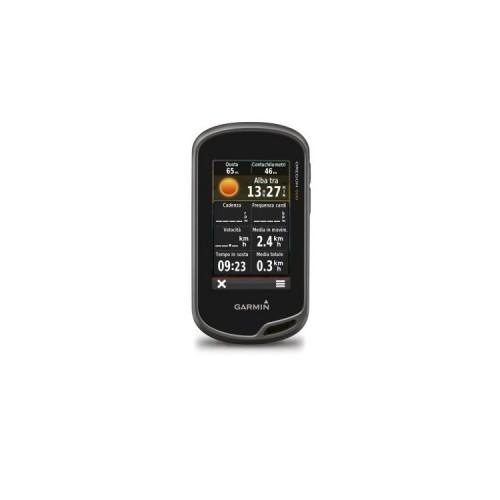
'The screen size (4x6,5 cm) is sufficient for the guide, manipulation of the touch screen is very convenient, the brightness is decent even in daylight with activated screen saver settings. It must be said that larger displays, it exists but it also consumes far more cell or battery ...
'We must invest in three cards if you love geocaching, hiking and biking: France V3 Pro for amateur hiking and geocaching (avoid ski touring with too many details are missing, but at least we have the lines levels!), City Navigator for GPS not sending you in every way streets in the city (this is what happens otherwise) and OSM Cycle Map if you like cycling (that one is free and in fact, as it is added to user contributions, it is above all others in many cities where cycling is practiced by prohibitions against it ignores the way).
Regrets
---------------
'Weight. Almost 150gr more than the CompeGPS Sportiva. With battery + carabiner I almost 300g ... and forced to take the charger from the iPad or a set of spare batteries. So in the end, 300g.
'Unable to connect the USB jack without removing the carabiner before.
'Painful ergonomic details:
- No direct access wheel for adjusting the brightness
- Is believed to have extinguished but no, he is idle, and the battery discharges. Garmin has no plans to beep to say that we have off, or check button like on an iPhone to validate what we want, too bad.
- The device turns back too easily, a simple push of two seconds on the right button!
'The gas plant submenus. Just to change the base map, for example, V3 Pro OSM Cycle, go to Settings -> cards -> Configure cards -> Enable or disable the one you want, then go back twice, close the menu, open the map ... Aaaargh.
'We use little enough eventually the possibility of having a navigation "portrait" or "landscape" by tilting the GPS: you end up deciding on a mode, and is held with a setting that forces the position ( Unfortunately you have to go digging through sub-menus to find ...) because it is infuriating to see if the screen rotate as soon as we move hand or strap of the backpack. I would have preferred a notch that blocks orientation as on an iPad, and therefore can easily unlock direction along the path.
Its best uses
-----------------------------
'Cyclists: This is a good report weight-screen size compared to other Garmin Montana genre more focused "geocaching" and heavier, with large screens and less autonomy, and Edge really dedicated cyclists who need to monitor their heart rate, but ultimately less concerned with the aspect of "hike".
The unit is waterproof, with a visible screen, with a small hook on the clicks on the handlebar bag, it is convenient.
'Geocaching: fine too. Large enough screen, and waypoints obtained free on Geocaching.com are installed directly on the Garmin in the "Treasures". Nothing to rename is "plug and play" ... once you have installed the right cards.
'Rando: not tested much, but the concern is of course the accuracy of the maps. The Garmin France V3 Pro is a big joke that is accustomed to the details of the IGN Top 25. It does not mark the old walls, ignores the GPS tower Township Birdseye ... and do not include IGN plots which one is accustomed us French. So finally I selected a few corners where I was hiking often and made the following manipulation. Hold: 1) I make a screenshot on Geoportal site of the Top 25 that interests me (basically, a rectangle covering 3 km long and 2 km from "top to bottom") 2) I save this capture as .jpeg, and I matter in Google Earth. 3) In Google Earth, I make the Top 25 coincide with IGN traced aerial picture of the real roads, and when I am satisfied with the result, I save and I generates a .kmz file with Google Earth. 4) I save the .kmz file on my SD memory card, and I matter on the GPS in the headings "custom maps". Counting an evening to 4 manipulation 'as well. Long, not practical, but free.
If a user really wants 100% hike and nothing else, I would recommend the CompeGPS Sportiva directly charging the base map IGN Top 25 on GPS. My father says and does good. The panel also made 10 km2 but at least we do not spend the evening.