[Housing and Display]
The housing of the device looks very elegant in my opinion significantly more noble than the current egg-shaped TomTom devices.
The material is high quality, there is no discernible gap dimensions.
The display consists of a capacitive touch screen with safety glass. The resolution is as with all other current navigation systems unfortunately far behind current level smartphone.
Individual pixels are so up close clearly recognizable, since it has a GPS but do not stick usually 20 cm in front of the eyes of the whole thing bearable.
The touch screen works very well for this, also pinch to zoom (zoom with two fingers) works perfectly.
[Map display and interface]
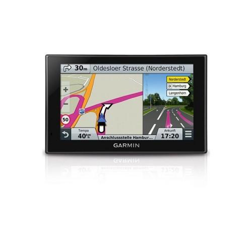
The presentation of maps is very pleasant. It's a good middle ground between simple view and colored illustration of landmarks such as lakes, meadows and neighborhoods. POI's can be displayed directly on the map and there are also clickable.
Unfortunately, 3D buildings and terrain are missing, but this is made up for with real Directions (see voice message) again.
The interface is quite classic and tidy. Compared to the current TomTom devices it is much clearer, colorful icons are in the apps used anywhere and the menu items of the settings are always so large that they are easily touch bar while driving.
In the address search you will traditionally passed and must first ZIP / city, then street, then enter the house number. Letters which are possible (no longer), since there is not the corresponding street names are automatically grayed out. I feel this way significantly better than the input as it is used by TomTom and most Smartphone Apps Maps, where you must fill in all information in a single line.
[Voice announcement and Navigation]
Announcements come quite often, but not nervous. As has been written in several reviews, the indication of the remaining meters will unfortunately from the junction center, the announcements come but always on time.
Truly amazing are the real Directions: We had announcements à la At the traffic lights / petrol station / at the stop sign turn left, turn right after the underpass and turn even when brick building on the left. That helps a lot, much more than the often poorly recognizable 3D building other Navis!
The acoustic signal when the speed limit is exceeded is for naught, as it gets going immediately if one is only 1 km / h above. In my Falk Vision 700 you could even set the benchmark separately for highways and motorways
Fortunately, you can turn off the signal, the visual cue then is still, however, is quite decent and nice to look at.
I have read many times that the recent Live a 3D representation of departures on highways like Becker missing. Indeed, there is this view and it is very well done, not only will be displayed at each exit. The screen is divided and the right moves a live display that realistically displays all tracks inside the car and a line shows what lane you should change.
I've attached a video and I hope that it is so apparent. Please excuse that the recording is so shaky - we had no tripod to avoid this.
[Route Calculation]
Here we come to the biggest drawback for me the Garmin devices!
For the route calculation, you can choose between Fastest, Shortest and most economical.
If you select eg the fastest, so really the fastest route is used. As alternative routes but not other fast routes are then calculated. Instead, the device calculates a route 2. always the shortest (which is actually proceed here very strictly according soon) and as 3rd most economical (which usually comes out cheese).
The problem is that the navigation does not accept the fact that there are also routes that are a middle of fastest and shortest. The following are only the extreme routes.
We often go between Erding and Munich-North. The default route that take everyone else I know Navis as a first choice (B388 & A9) it does not exist at the Nüvi. Instead, is selected as the fastest route one (but thanks to highways a few seconds faster) is 15 kilometers long and the shortest one way which leads completely highways.
In my Falk Vision 700, there was a so-called. Optimal route, which was just a reasonable balance of fast and short. Such a thing does not know the Nüvi
The whole thing goes even further:
The Navi adheres so strictly because only the fastest and the shortest route indicate that, without further ado at all indicating no more alternatives in the event that the fastest and shortest one and the same route are!
It so happens that at the Munich - is> Berlin proposed a single route. I can assure you: There's more than one! Just bring that to the Navi in ...
[Traffic]
The traffic display works thanks HERE Maps on DAB + super and can accommodate almost with TomTom HD Traffic. Detours around traffic jams are then calculated clean. :)
[Apps and Anwedungen]
Short touched:
- The Smartphone Link app is fun can be information such as weather, opening times, current radar information (chargeable). call etc. with the help of the data traffic of the mobile phone.
- The phone app (Bluetooth) works perfectly, execute calls in the car always on the Navi.
- The Eco app is very useful and calculated after each completed route, the running costs and provides tips to save fuel.
- The PC application "Garmin Express" is very simple. Updating the card is very easy and very fast. There are a few extras installable like other displayable cars.
[Conclusion]
The Garmin nüvi 2569/2599 is one of the best navigation systems on the market with a very good route guidance and always current traffic data.
Only the route calculation is driving me insane regularly and has already made sure that I locked my hand some roads so that the Navi calculates another route. This is a clearly a star deduction for me.
Finally, a quick note:
I own the Nüvi 2569 so the version without voice control and with maps of Central Europe. This version has over the more expensive variant but one advantage:
The smaller number of cards, the internal memory is only half full. So there is enough space for installing extras, radar information, etc. An additional micro SD card is not necessary here. :)
+ Cleaned up Interface
+ Capacitive Touchscreen
+ Beautiful and liquid map display
+ Current traffic information at no extra charge thanks to HERE Maps and DAB +
+ Good voice guidance with particular appreciation thanks to Real Directions
+ Splitscreen display for intersections and departures
+ Many motorway exits Live 3D road layout
+ Useful additional features such as ecoRoute and Smartphone Link
- Route calculation suboptimal: No "optimal" route selected
- Maximum Warner because no km / h threshold is meaningless adjustable
- No 3D buildings / -Gelände
- Low Resolution