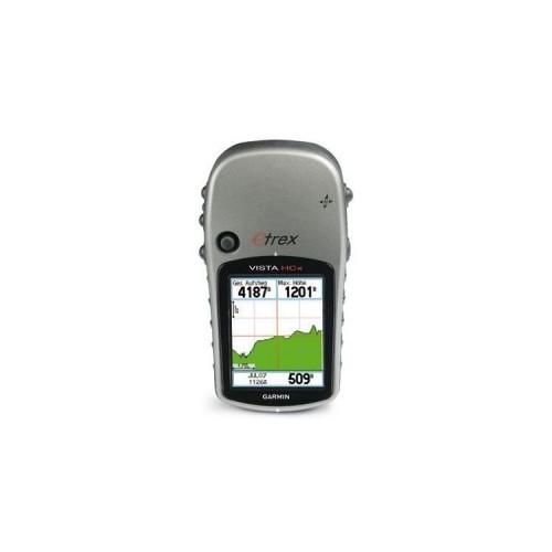
By now I've made a lot of practice with the eTrex Vista HCX and I'm still excited. The more I open up areas, the more surprised I am, how well the device is also suitable for different applications.
However, it must be said that Garmin's strength clearly lies in the hardware and the software that runs on - but by no means in the supplied Windows - Software. I use only rarely to make, for example, firmware updates.
The nice thing about the Garmin products is that you a smorgasbord of free software for both Windows and Linux (I myself have both systems in operation) will, with which one then can do the everyday "real work".
2. maps
Rather disappointing as I give to the critics right, is the included base maps, which contains only the main streets, so that for example the auto-routing can not be used seriously.
Where probably every buyer will be clear that this is not the focus of the device.
Who needs a device mainly for the car is eg better off with a TomTom.
Worth mentioning at this point are the "City Navigator" cards that are in my opinion, its money value.
If the focus is not the autorouting, then there are a lot of free maps (street maps and topographic maps) that can bring about the corresponding programs (eg QLandkarte for Linux) on his device.
In addition there are even finished "Images" which you can simply copy it to the device. Here are just a little Google research is necessary.
An interesting project in this context is OpenStreetMap - ie free tickets, which can be extended to the wiki principle of everyone.
3. Application Areas
Well my experience with the use of areas that I use.
3.1. (Mountain) -Radeln / Hiking
Because I can not imagine what I might like to see more at my time ...
Driven / migrated routes can be easily recorded and analyzed with tools such as MyTourbook and archived. Of course you can advance the route (either create yourself or simply from one of the numerous websites) playing on the device, which is then migrated / abgeradelt.
3.2. Geocaching
After some training in the area and the available tools (eg cache Wolf combined with gpsbabel or PoiLoader) has soon found the suitable ways to bring the cache on the device. Paperless does not get off, but but with some Getüftel it also brings the basic information (ie for the "traditionals" to get without paper).
3.3. Car
Yes, I use the device in the car and was surprised myself how well this also with the (compared with the usual equipment) relatively small screen and without a voice output (instead it beeps) works.
Sure, you may the car radio does not have switched on too loud, and it is safer to compensate for the lack of speech by a passenger or a co-driver (as well as TMC and Lane Departure Warning have to do without), but the software is in my opinion really good - the key pictures (intersections, traffic circle, ...) are displayed at the right time at its maximum size, so that you captured with a quick look, where to go next.
Anyway, I've decided that I will no additional navigation system buy specifically for the car, because I would use it too little and the Garmin does the job.
3.4 Map
here is the small size and long battery life an advantage over the car-navigation systems. Furthermore, the display is still quite easy to read even in bright sunlight. When I'm on vacation somewhere, I take the device with always. To find back to the car, for example I use just a waypoint and then let me in an emergency - if I lose the orientation - navigate back :-).
4. Statements
Before I suggest me to praise I want to finally come to a conclusion.
My Conclusion:
For this price you get a better device (in my opinion).
Update after a half year practice:
I'm still technically satisfied with the device.
However, now the device spanning rubber has come off on my Vista. The adhesive used does not seem to hold permanently and dissolves in warmer temperatures.
But as I've grown fond of the device, I have (instead of returning it) the adhesive removed with white spirit and stuck the rubber with Sikaflex again.
Anyway, there is this clear deductions ...
Update in October 2010:
Even after more than 1.5 years, I'm still totally satisfied.
In the meantime there are routable OpenStreetMap maps that are slow (depending on the country) a real competitor to the commercial cards.
Update in June 2011:
After 2.5 years I use the device still regularly - my smartphone can not compete because (battery life!).
Meanwhile, the supplied clip has the time blessed. On a US side, I could get this to a few dollars (the einzigedDeutsche page I've found this demanding outrageously high cost of delivery to Austria).
A separate car-Navi I still do not - my eTrex has proven itself in various Urlabsdestinationen (including in a US city).