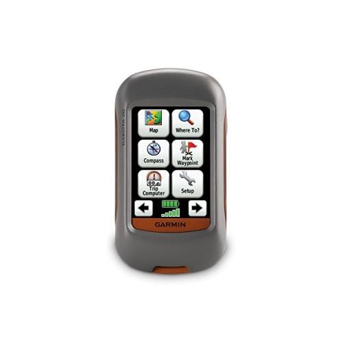
This is my first purchase of a GPS hike and I must say I am pleasantly surprised at the opportunities offered by all of its functions .. I rather regret the lack of serious support for the use of such a device but after searching on the web and a lot of practice I finally get a mode otpimal of my Garmin Dakota. Here is some information that might be useful to novices who would like to indulge in buying this camera, like me! After receiving your Garmin, you must download the BaseCamp software (it's free) on the Garmin site, then install it on your PC. It is in this program you can define your future routes, measure distances, type of export GPX files that contain all specific stastiques (such as altitude, for example) of your tracks done and do many other things yet. One important thing to remember: let your Garmin connected to your computer (with the supplied USB cable) while you use BaseCamp, allowing you to transfer in real time all the data you create (such as waypoints, routes, plots etc ....) and above you can load the maps that are contained in your Garmin on your screen while you use BaseCamp! Because the cards are another very important aspect of this unit. Your Garmin comes with a preinstalled map, a very rudimentary map of the world which will certainly not be enough for you. On the web you can find free maps and a proper level of detail, what we must remember is that you should look for cards are .IMG file type. When you have, copy / paste them directly to your Garmin or, if you bought a micro SD card (SDHC works too) to increase the amount of memory you have available, you can also copy / paste your file directly on this IMG SD card in a folder you have created and named "Garmin". You can stick as many files IMG you want (within the limits of the space available on your micro SD card of course), but your Garmin Dakota can not display more than 5 same time, for what I have found. it's not bad and gives many possibilities (one can imagine such a topographical map and a Road Signs, region, superimposed on a map of the whole of France for example). Finally, all the maps on your Garmin will appear on the screen of your PC when you use BaseCamp leaving it connected via USB, which is very useful.