
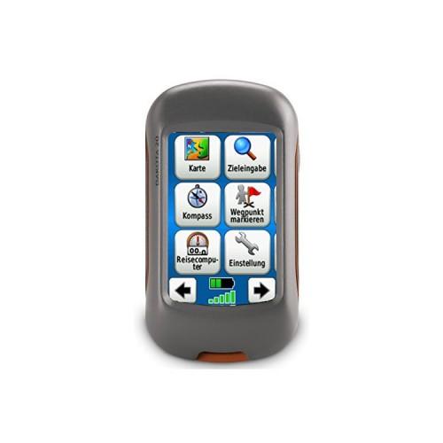
Once I actually almost two years flirted with the Oregon-series, I now decided within a few days for the Dakota 20 with additional 8GB SDHC card and I am not disappointed after a few days of trying and installing - rather, I'm really excited about the little device that (now) is attractively priced and almost an all-rounder. The Oregon still seems to have display and battery life issues after the reviews. In addition, the price range of the Oregon well above the Dakota 20 is a chance encounter at a Geocaching Geocachers also told me of his negative experience with Oregon.
The Dakota has virtually the same compact dimensions of Vista with an equal display of 2.6 inches. The display is absolutely fine: there you need no daytime lighting (Transreflexiver color TFT touch screen), evening and at night the lighting is not so much light than in Vista, but absolutely sufficient. An anti-reflective screen protector is helpful, but need not be, because you can turn the machine with a handle so while hiking that reflections do not interfere or appear. But the film as a protection from scratches is an absolutely sensible purchase. So protector is compulsory, antireflective or glossy is a matter of taste.
Important first update the firmware using the Garmin-Updater program (free download) and registering with Garmin and a backup of the system files on the computer.
After some problems (typical rookie mistakes: lack of unpacking the download map data) running OSM maps (always on a memory card, never install the system!) Properly. You have to search a bit until you find the maps, the one of the representation (lines, surfaces and colors!) Like and suitable for the targeted use provides details. When hiking, for example gates / doors are important to me as an important guidance. Maps with all OSM features are often too full, too large and therefore slow. Are selecting it on the relevant pages. Mir said openmtbmap to most and the maps of spatial reference.
TIP: prefer to install smaller individual country maps, as a map of Europe with all countries. When map files over 1.5GB (per card file gmapsupp) the processor is clearly in the knee and the start-up after power, scrolling and the search input are extremely slow! Was therefore initially frustrated until I installed instead of Europe-total individual maps of interesting countries - because everything was super fast again! Maps and overlays (such as contour lines) can also enable / disable individual menu.
The Dakota accepts any card name (not only gmapsupp!), Which helps to keep the overview. Lithium batteries (Energizer Lithium) show, even after several days of testing still full power. But will try with 2700 mAh NiMH batteries on holiday. (Garming recommends a minimum of 2500 mAh.)
Helpful when dealing with maps, the Garmin programs "Mapsource" are (is the Garmin-purchase tickets and I had the Vista) and "Base Camp" (free download at Garmin). Be careful: some download maps to be installed only on a detour via Mapsource / Basecamp. Only the so-called gmapsupp.img files can play directly on this product!
In addition to the cards, you can now recently Load satellite images / aerial photographs on the Dakota and inferior to the cards. Garmin is the BirdsEye and costs 25 euros per year. But you can download a trial basis (larger) areas for free in Base Camp and to investigate usefulness (resolution / cloud cover / brightness / shadow) before completing the subscription. Smaller areas can even download for free for testing purposes. Nice gimmick whose benefits largely depends on the quality of the recordings. After first impressions the images in cities seem to be as useful in the wilderness. The resolution of the highest quality is so good that you can see non-mapped trails in the wilderness! You can choose four different resolution levels. The size of the download files from BirdsEye server is limited for some time to 75MB, because the server was probably overloaded. This corresponded to about 90 square kilometers in my download of the highest quality.
In forums but is also reported from the free ability to create with Google Earth even these overlays. But it seems at the moment still a bit cumbersome, but still to be quite feasible. Basecamp installed the images automatically without choice in the system in the main folder "Garmin" in the subdirectory "Birdseye". I have not tried to move to the memory card, the file - but would actually be possible. Because Garmin advertises unlimited satellite imagery - which of course eventually have to reach our limits with 850MB main memory of the Dakota. Google Earth always doing offline for a region - that's what!
For Paperless geocaching you need although a premium subscription at Geocaching.com for 30 dollars. For this you can but as so-called Pocket Query create a collective list of caches and have it sent via email. The GPX files to an area previously defined (up to 1000 caches, restriction Pocket Query) then include all descriptions, active trackables (eg Geocoins and travel bugs) and the latest logs. In a second file being sent with the helpful waypoints (eg parking) are transmitted to the caches. These two files should be installed in the folder "GPX" in the main folder "Garmin" the memory card. You just have to do without the photos and spoiler photos for lack of image viewer in the Dakota. So can be in a single operation in just a few minutes up to 200 caches (restriction in Dakota GPX) completely install. So a huge time savings for individual download loc files and printing the descriptions of normal membership.
The operation of the touch screen is very pleasant and fast. The visual keyboard is easy to operate even for longer text entries. Problems could get only those with "sausage fingers", as the display happens to be rather small and deepened in the device is. I do not want to say much about the other feature important to me was the 3-axis electronic compass, which works in any position in the state and the barometric pressure / altitude meter. The Dakota 20 drives very fast high (if you installed is not to large single-card files, see above) and is there in about 10 seconds. Position determination is there and a shorter turn-off time already immediately after the 10 seconds, with complete re-locating the device remains significantly below one minute.
As an accessory, I ordered the original Silicone Case (Silicone Case, Amazon: Garmin protective bag for Dakota 10 Dakota 20), which protects the device round on 4 sides in crashes. The device is thus somewhat beefy, but a ground landing can prosper very well tolerated with this package. Displayfolie should of course be to protect against scratching, but a display landing on a sharp stone would probably still the end. But as might help to avoid the worst of the recessed installation of the display. The great thing: This case fits the Dakota 20 again perfect in my backpack bracket from Vista (Amazon: Garmin mount for backpack, eTrex family) that has proven to me in recent years than ideal. You get the device close at hand and with safety line on a Velcro surface on the backpack straps. This position on the shoulder also ensures best GPS signal reception, even if this is no longer as important as in the Dakota Vista CX.
All in all - a little miracle device and a huge step forward for the eTrex Vista Cx.


![Hawaii Five-0 - Season 2 [OV] (Amazon Instant Video)](https://img.tgreer.com/thumb/85x85/5/d8/5d8689ef3e5fa785ab697eb353c6edad.jpg)


![Dead Space 2 - Collector's Edition [PEGI] (computer game)](https://img.tgreer.com/thumb/85x85/7/7c/77c16b3a579d3dd34e1f66841c425f34.jpg)