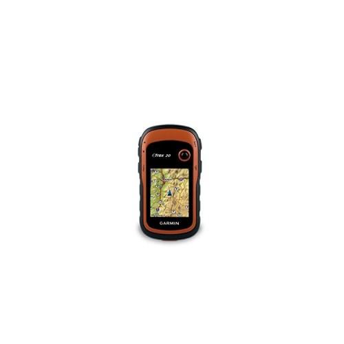
The main finding was already in the preparation of the walking tours: Without proper maps, the GPS device is only very limited use. The contained very basic cards are only conditionally usable for hiking. It is quite clear that without knowledge of the topography of the hiking area the benefit is very limited, so I invested in the trip from Garmin Map "Garmin Topographic Map Topo Spain V5 Pro", which, however, almost costs as much as the device itself .. . somehow presents itself as a bit the same feeling as in ink jet printers or capsule coffee makers a ... the appliance is pricewise OK but the "consumables" are expensive ...
However, it must be said that there are also many other (partly free) tickets, especially from the Open Streetmap Project, are but I just did not have time to concern myself sufficiently with the alternative products. And in fact the quality of the purchased card Spain is very high, it meets the standard of a 1: 25,000 hiking map.
Now for the review: I have the power obtained with a micro SD card, the topographical map above as well as the GPS data of the Rother hiking guide "Tenerife" (which I also bought on paper) "upgraded" and had me so plunged into the adventure Tenerife.
Result: With the described combination (GPS Navi, map and tour dates) to win significant security to the partly tricky mountain tours. The risk of "Versteigens" is significantly minimized by the zoom function! Questionable branches or even bad descriptions in hiking (about elsewhere more) are compensated for by the use of available by Rother publishing GPS data. The loss of time due to wrong turning or the Versteigen in difficult terrain is markedly reduced. I think the Garmin eTrex 20 is to accompany all my mountain tours in the future if I can afford the maps / wants or just find good free maps. Also I'm going to invest in accessories: The device comes almost "naked", ie without case, strap or whatever. So I kept the device on the tours almost permanently in his hand, which is somewhat impractical.
Review:
+ Robust, small package
+ Good presentation of maps and tour dates with or without backlight
+ Wide range of functions (which I could previously only be used in part)
+ Long battery life
+ Easy to use
+ Garmin offers great software to tour for free (at least something that does not cost extra)
- Only partially usable without additional (and sometimes expensive) maps (but the acquired map material is super !!!)
- The device is delivered without any additional accessories, which has to be bought
- For the device registered maps can only be used on the PC when the device is connected via USB
Conclusion: The eTrex 20 is very well suited, provided it is equipped with appropriate maps for my purposes (hiking / mountain tour). Even a little retrofitting with bag and backpack for example loop is worthwhile in any case, and I have by far not yet exhausted all applications (as me certain things, such as geocaching) not interested). As noted above: Little Helper is now always with you!
The withdrawal of a star there for but very basic facilities with accessories and maps.