
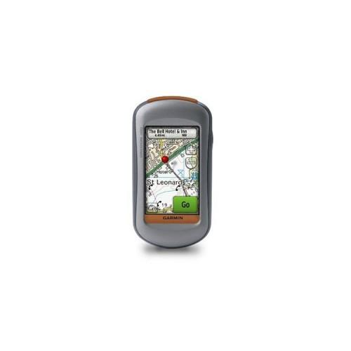
Turning works with the single control button on the right side (at the same time the key for lighting), all other functions are carried out directly on the display on the touch screen. Some might think, a touch screen has to look for outdoors because of the dirt nothing. But works flawlessly. I even wash the screen when dirty with plenty of water and from wipe not dry it - should we indeed handle in the sun glasses so. Since we are in water: So far, proper functioning, even passed a rainy ride on the bike already easily.
Hardware
The device itself is due to its shape well in the hand. Additional I to the car kit, a bicycle rack and a chest strap for heart rate measurement (yes, read that right, and that's why my decision was, inter alia, on the Oregon 300).
For the navigation in the car my device ranges together with the map of Europe completely, even if no voice prompts occur. Surely there are better devices for this purpose. I know where I am, see the route on the display, in a turn I get a beep in advance.
Bike Mount:
The unit sits snugly in its holder. Even with rough use and violent blows to the MTB holds unit securely. The bracket can be mounted with cable ties both the handlebars and the stem simple, no matter what diameter pipe.
Chest:
The first time pairing with a device is necessary, then does the transmission of heart rate to the unit properly (digital encoding). Even from up to 5 meters with absolute reliability. Only the wide and rigid plastic mold of the chest strap seems overtaken me something as a development to take place. Still wears relatively pleasant.
Batteries:
With two conventional AA batteries of Oregon is operational. Garmin recommends itself quality NiMH or lithium batteries. In the former I use Sony 2700 mAh, I hereby Reach maturities 10-12 hours. With the lithium I manage a little over 20 hours. However, these are relatively expensive. Better to invest the money in a second or third set of NiMH batteries.
Memory:
Internal 850MB can be stored on cards. Additional to MicroSD cards up to a size of 4 GB are inserted. Cards are pre-programmed to buy or DVD you can buy and have the software then simultaneously on the PC and the device. Who is at loggerheads with the PC buys best the MicroSD card, but then brings in my opinion, to various possibilities of GPS navigation.
Software
Now we come to the real, the GPS navigation. The position is determined within a few seconds, even in the forest, I never had a misfire (which seems to be apparently in older devices, the rule).
The map display for driving is impeccable. If a route is activated, the map zooms in achieving a greater Abbiegepunktes automatically, then back to the overview. For my outdoor applications I have additional topographical map. And this view is just great. As on a paper card is a plastic representation of the terrain, hills and mountains are shown with shading. One really needs almost no longer the contour lines shown to recognize to know where to go down and up. The only drawback here: the sun shines full on the screen everything is fine, super read. With strong cloudy sky or at dusk is not much without backlighting. Remedy: If you follow a track, these represent in a bright color, such as red or pink.. The stand out well on the map.
In addition to the regular menu, there is a 3D map display. For myself, uninteresting, because I am from map already can orient well. In addition, the card structure takes something and should consume quite a bit of power probably. For some, however, this may be an interesting feature.
On most pages, data fields can be displayed as desired and replaced. That said, I can freely choose what I want to have displayed, for example on the Map page or dates page of a total of 44 different data fields. Km, time, stopwatch, heart rate, altitude, altitude, GPS, speed, ... There is something for every find the right image.
Like an iPhone can slide your finger across the screen are scrolled, or quite conventional on arrows shown on the display.
The barometric altimeter provides a height profile on the relevant page in the evaluations altitude match exactly with my bicycle speedometer - who has probably had its day soon. The everything it can, also works with the Oregon.
Since a partly filled with user update the height profile is also zoomed. Here also some translation errors have been corrected. A few still exist, but think that belong with the next update also to the past.
Tracks / tours
On the Track page (Track manager) several tracks (tours) can be saved. Of these, then more can be displayed simultaneously on the Map page, also in different colors. Often I have available for a longer tour a shorter alternative. Thus see at any time, when and where I can get out of the original tour. Tours can be recorded in any length and save or transferred to a PC for further processing or display. Even the exchange via radio to an identical device should be possible, provided that the device has the same technique.
Profiles
Different user profiles can be created and will then be selected as required for various applications, eg. For example, geocaching, automotive, sports, marine and outdoor. Of course there can also be other specifications, such. As for paragliding.
Geocaching
Geocaching has become a new hobby of my daughter. Since we were the first time together at a Treasure go is no longer to keep. But also has a great feature:. Treasure "choose among geocaching.de and transferred to the device, since I registered here also the description of the device are transmitted with, a nice touch.
Conclusion
Versatile device, robust and waterproof. Device has its price, but it is worth because of the many features.


![Patuoxun® multi-function car JumpStarter [Automotive] emergency power energy station 15000mAh Power Bank battery charger [12V / 5V / 19V, 2A / 3.5A] (Electronics)](https://img.tgreer.com/thumb/85x85/a/b1/ab111a371f752551d28f229d154a5e88.jpg)

![Volutz® 5-Pack 1m Premium Color-coded Micro USB cable Cableogy Series Fast Robust charger cable / data cable for smartphones Phones Tablets (Samsung Galaxy HTC Nokia Sony and more) USB 2.0 A Male to Micro B with strong nylon coating (in blue red yellow green and orange) [24-month warranty] (Electronics)](https://img.tgreer.com/thumb/85x85/0/bd/0bd1f263cb5f35a4.jpg)


