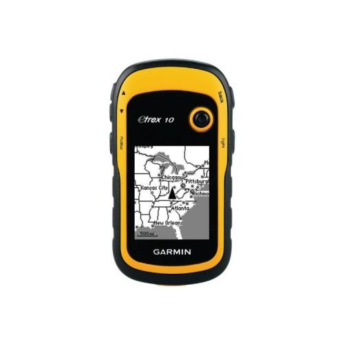
The device provides highly accurate position data. It may in addition to the GPS satellites also use the GLONASS satellite system. The rubberized and sealed housing not seem outdoor-ready, the power consumption is too high. If you have something incorporated into the use of such devices is about following applications are emerging: 1. The device logs with a hike, a bike ride or drive. It is characterized waypoints on at appropriate intervals. These distances are shorter than for a drive with a hike. To repeat this hike or ride, can you look at the Tour Show the path line. A cursor indicates the direction then using the current location exactly whether it is in motion towards the left or right of the desired path or is correct. A detailed map image is not absolutely necessary. 2. One enters a single waypoint, for example, a geocache in the device. The device then a sounding line from the current position to the desired objective. The cursor indicates the direction of movement. He shows towards bearing line goes or you go right. If not, he gives notice to the direction of correction. Also works without detailed map image. Here you can be better still like to spend as the ship's compass a large arrow in a compass rose with the current distance to the target 3. Man created on the computer using the OSM (Open Street Map) cards or even with Google Maps and a partially cleared TrackPoint Software a GPX file with a list of waypoints or routes, the so only with each other in a particular order associated waypoints are. The GPX files have XML format, an advanced web format and are the foundation for all data storage and for data exchange and data backup to the computer. Only the map displays use a different format. The device can display maps, but the non-expandable memory limits the accuracy and / or the map section. This GPX file with the prepared computer Tour will be played on the device and serves as the basis for navigation. With a little flexibility, a detailed map image is not necessary in my opinion, at least not on foot and by bicycle. 4. It has a slightly more expensive device with a memory card slot and color representation. This also large and detailed maps can be inferior. The limiting processing power and also the small screen but require also here that one adapts to the characteristics of the device: The cuttings need time to build up, particularly for rotation. That is for me, one is well advised, in this case, prepare the tour at the computer, at least in an unknown environment. Possibly in such devices, the power consumption is slightly higher. This is my first GPS device and I was very pleasantly surprised by the exact function of the device, as I said before, provided some training or knowledge.