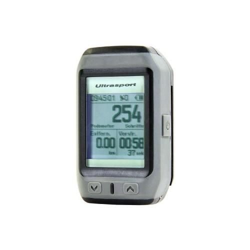
What does the NavCom 400 for function? The NavCom 400 recorded time, distance, speed, number of steps (however, the pedometer is not 100% accurate), position (continuous tracking), and elevation data. Of course, this data is displayed in various forms, such as speed or average speed. The relevant data is displayed on multiple pages, which you can scroll through with two arrows. Plus, there's a third button with which you turn on the device and enters the sub-menus for various settings. After a short settling time allows the NavCom 400 with these 3 buttons easy to operate. On pages already addressed now find a wide variety of display patterns and functions. You can display a height profile, use a stopwatch, record lap times, GPS analyze data, use a compass andd en pedometer. Particularly noteworthy is a Trackingmap where the running track is with drawn. Although the NavCom 400 has no cards work, but for cross-country runs, this is a great feature, since you can easily make return to the starting point. Also you can always store its location as a POI to later find back. Another noteworthy feature is uploadable POIs because the NavCom 400 interesting software is also included. So you can connected to the USB NavCom 400 on the one hand the captured data in an analysis program (calories, distance, time, speed, etc.) upload, but also plan walking routes or running routes on the PC and play as POIs on NavCom 400. This then indicates the direction, distance and estimated time of arrival to the next POI. Since the track may consist of a chain of POIs that works almost like a route planner.
Let's talk about accessories. Of course, a micro USB cable for data transfer and battery charging is. Here, too, is a holder for a bicycle handlebar and a silicone bracelet, bringing the NavCom 400 can wear like a watch. The dimensions of 400 NavCom be here 6.5cm x 4.0 cm x 1.8 cm, which seems pretty clunky because of the altitude, but the weight is still quite bearable. The design is very clearly designed for rugged outdoor use and provides little Schick. The illuminated display is designed monochrome but clearly.
In summary, one obtains a great outdoor instrument with practical software. Innovation potential is clearly in the field of reduction and the faster GPS willingness or the better GPS to find reception.