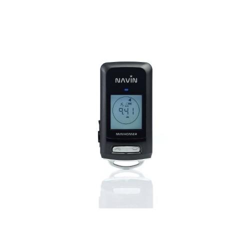
first: the dealer / manufacturer even makes a mistaken good support and advance all questions answered. no annoying "hotline". rare these days, the dealer to get directly to the stripping. improve the interest in the device is large. Just try to convey their experiences directly to a human in eg Nokia. the update page is clear layout only the description is misleading; The device is called miniHomer 2.3- the update version of the software but is 1,444. thus you are afraid, the unit "downgrade" Software update for the "First Step Guide" Read ... important! the device- really like ne mini zündholzschachtel- the housing is limited to the wesentliche- here no inflated "Xpod" is sold at inflated design awards. nevertheless could have a housing guard the, because it is "natural" often fällt- down operation 2 veeeery small function key twice the size would be good Display simple s / w with clear numbers and symbols. Cover USB connection of gumistopfen is pull out only with a knife. * umständlich- here should be a tab attached. Menu Despite only 2 buttons actually logical to use. ie in any point leads under the auführung of equal steps at the same function position data input is, contrary to the review the Florian, well possible- only you "preset" the O / W or wide turns around by itself, and is no longer to propriate corrective here it takes a lot of exercise. the trip software is particularly convenient under the menu item "miniHomer". here you can just "Enter stay (POIs before, with 5 important coordinates)" Move enter "on the map and transferred to the device Function: if you miniHomer keeps in his pocket, or while running in the hand, in the software "Trip" displayed route already deviates greatly from the realiät. (Also the setting of the saved points gives different "path pictures" for this purpose it is advisable to also, the sample images to study in detail.) the device should always be kept horizontally forward werden- happy you super. display the destination course as the crow flies .. (it's plain no card on it) and the arrows employed persons decreasing number of meters help tremendously to get back. Also you can turn the device to the destination, and the estimated direction. IMPORTANT- city maze by car, only change the direction, if the arrow is pointing away from the already 90 degrees direction. MINUS: Only 5 points werden- saved for a route preparation, or "stake out" a track off-road (car ....) should already be 10-20 points possible. also should own wording of points instead of hearts and little arrow symbols Being possible at least in the travel software. This is but the display and the unit is supposed to remain competitively priced.
Software Package: the shareware is free released after connecting the MH. the aufgez. will stretch beautiful interracial dargestellt- on Google Maps. The Ups And km profile can be read. MINUS: the pull of the symbol to a point on the map is very tedious because the map zooms out again when you release the cursor. Accessories: The unit comes with complete with USB cable (which nowadays have not even printers) and 220v and 12/24 volt adapter supplied. GREAT
for me, as a beginner, the almost ideal device- for acceptable price.