
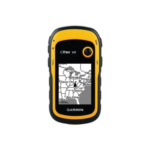
Basic settings
In addition to the Internet Garmin eTrex 10 Setup settings proceed Tipps_GPS expertise Navigation Professional. Especially the automatic saving of "Tracks" opt out. Otherwise müllt you look at the memory with useless data fully.
Clean Up Menu
Push the sides upwards, which you really need, in this case satellite Waypoint - Waypoint. The rest can stay below and does not interfere so.
Save waypoints
Sealing go to the point to be stored zoom. How should the device know that the point to be stored in 15 m distance is? First call Satellite. There, the satellites are not only shown with respective signal strength but also on the top left coordinates and especially in the "GPS" the blur radius.
Accuracy:
The measurement will be more accurate if you meet the advertising the device (especially after switching) time allows - will continue to be displayed until the blur 3m. Here, the position display will change yet. This is a clear sky faster (and more precise), in the drizzle in the forest can it ever take a good minute. Please do not take literally the expected deviation of 3 m, 8 m are often realistic. However, I have an open area with a clear sky only 1 m 2 located next to (compared with cards DGK5 / ArcView).
About "BACK" button to the menu.
Call "waypoint", enter a password under "Note" for example, or waypoint number. Write (at the top). Go via cursor to "Finish" and save by pressing Thumb Stick. Who suppressed immediately Done can then call the waypoint by "Waypoint Manager" and resent an identifier. Unfortunately, the device sorts the waypoints neither numbers nor by recording date but apparently mixed arbitrarily. It's annoying when you want to later call a certain point in the terrain.
Save GPX files on computer
The device sets for each day with storages to a GPX file. Connect the device via USB cable to computer. Select mass storage mode. About Garmin / GPX open a file. This goes by Editor or clear with Excel. The following three choices. Choose the middle option "read-only workbook". Copy only the coordinates, altitude, waypoint no., The registered notice (WPT / CMT) and date and time in your list to be saved. Everything else is garbage for us.
Waypoint Map transferred:
You do not need the expensive cards from Garmin. The device is not intended for it. The memory is too small, and a map display in the size of two postage stamps is anyway of dubious value. Use Google Maps (coordinates in decimal degrees only copy comma separated command line, green arrow shows the point) or enter the waypoint or -No. the TK25-paper card (copy) fields. It even goes quite well, if you convert to Gauss Kruger coordinates in meters. This makes for you "deine-berge.de/umrechner_koordinaten" an Internet-converter eg. Unfortunately, that can not display etrex10 GK coordinates.
Basecamp:
Download the program for free from the Garmin website. Pushing away the annoying pop-up windows, connecting device, change to mass storage mode and open the saved files in the left column of the BaseCamp window with a mouse click. Waypoints are shown below with numbers. Double-click on a waypoint opens a Properties window with all the stored information. The type of coordinate display may be chosen under Utilities / Options / Grid. Here goes Gauss Kruger. On the second tab can be registered under "Note" comfortably on the keyboard still of several text. You write directly to the device's memory.
Now the waypoints you can view without Garmin map on Google Earth also. For this purpose highlight the waypoint to display and select the View / Google Earth / selected items.
On my old PC (Windows XP, 1GB of memory) is the good - but Basecamp rödelt when closing firmly regularly, while the CPU is running at 100%. Since helps a trick: Call Before Task Manager and afterwards finish the entry BaseCamp.exe under Processes. On the laptop (Windows 7, 4 GB), the program can even (mostly) close. Garmin seems to concern not only unimaginative Instructions writer but also special programmer.


![FIFA 12 - [PlayStation 3] (Video Game)](https://img.tgreer.com/thumb/85x85/0/5f/05f50106810809e56e6520ee7613c82e.jpg)


![Middle-earth: Shadow of Mordor - [PlayStation 4] (Video Game)](https://img.tgreer.com/thumb/85x85/2/3a/23a4d0ef19f280b0.jpg)


![Alien: Isolation - Ripley Edition (incl. Artbook) - [PlayStation 4] (Video Game)](https://img.tgreer.com/thumb/85x85/7/c8/7c82dc9bfde211a4352ed86a0ee92dbe.jpg)


