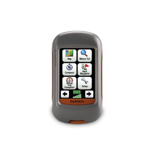
strengths:
* It is very ergonomic - when looking around we see that is highly configurable -
* Autonomy is between 20h - with rechargeable battery 2700ma - and 22h with normal batteries and the energy saving mode enabled and brightness to the lowest
* It is compatible with the OSM maps (openstreetmap) - far more accurate than the "real" garmin cards; dear, what is more quickly out of the game for updates. PS: it is fully plug from the preinstalled card because if you bought this type of product is that you are informed, we do not disburse 250 for nothing.
* Use the touch is a plus. The other advantage is that you can create layered maps with OSM
* Even in configuration - in the forest etc, the signal remains strong.
* It is waterproof
* Very good accuracy: between 3 and 5m (think about changing the mode in the parameters of GPS, do not stay normal)
* To protect the screen it is advisable to buy a protective film (3)
* It allows to share data between GPS (like any garmin)
* For my part the screen is more than enough, again for the cranky, you can go to the Oregon 450, but it's the same price or the same weight in the backpack .....
* Basecamp, the software that manages the route, POI ... etc and pretty good if I fichu.Même advises Qlanderkarte software that is powerful and with more precise maps.
* The outer shell is resistant
* Very lightweight for the hike
Weaknesses:
* When trekking it is advisable to lock the GPS
* With version 5.20 of the firmware garmin, turning down the brightness does not work every time, whereas with the previous version that was not the case and oddly, autonomy remains high
* Indeed, with the sun in your face, it is not necessarily easy to read what's happening on screen, but in 4 seconds is corrected, it is enough to turn a bit and change the orientation of gps
* Rubber to protect the USb port is not especially well done
* The size of the internal memory is too small, I strongly advise buying a microSD card especially if you want to put a lot of data: KMZ, GPX file, track etc ....
* Plus the card is great and idle GPS (I still remember once that it is a walking GPS so you generally regions)
note: as I said earlier I tested the etex30 along the garmin on hikes.
roughly the eTrex 30 adds nothing more than the dakota20. in addition the screen is smaller. The manipulation with the jostick not that simple (it takes well over manipulation to create a real POI with etrex with dakota - eg change the name -). Obviously garmin changed the internal parameters of the device, because if I put my multilayer board OSM in etrex, the map has only one layer .... damage). autonomy between the two is almost the same (2 hours more with the eTrex). by USB protects against the etrex seems best BUT the rubber layer seems to me thin, too thin.
Here, if I think could help .....