
I bought it to GPX tracks to download from the relevant portals on the Internet or even to plan tracks on the computer to then be able to easily descendants.
The Edge 800 is easily recognized on both Windows 7 including Linux (Ubuntu) as a storage medium. Tracks can then be loaded into the "/ Garmin / NewFiles" directory. The next time the device it will be displayed under "distances".
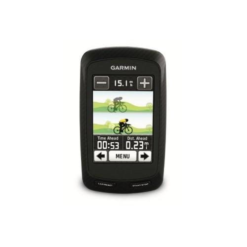
From there, they can be displayed on the map and the options you can activate the turn by turn (on routingfähigem maps). These work with the "All In One" Openstreetmap better than I expected. The Garmin leads me exactly along the downloaded tracks and displays about 150m and 50m in front of a branch turn by turn by a large white arrow on the map zoomed in on.
It differs from the track, warns the Garmin means beep and then routes back problems continue when you reach the track again.
Every now and then it may, depending on the road for about superfluous instructions come what probably lies maps. However, this is rare and acceptable to me. Car navigation systems function not always perfect.
The free routing to a specific destination works similarly, but I have not yet been tested too much.
The recorded tracks can I synchronize the time using the free software bikeXperience Linux on my computer. But you can also read the .fit files from the directory "/ Garmin / Activities" via USB and example Import GPSies (and convert).
Since the Garmin but also makes a good figure as a training computer I think about still buy the chest and thus abolish the Polar entirely. The free configurability of displayed data fields is exemplary. The determination of the distance traveled, the instantaneous and average speed works so well by GPS, that I do not necessarily think the appropriate sensor is necessary (at least for the good weather the last 4 weeks).
Detrimental to a training computer do I find the battery life of ~ 14h. This drastically decreases if and how bright the backlight is turned on. The display is, however, fairly easy to read in daylight without lighting. Only the appearance of strong reflections a bit disturbing. Here you should use a duller display. The readability of the card is thus slightly limited. The descendants of a track only to representation on the map without turn by turn - as often used by MTBlern - could then especially in shady woods are a little difficult (the transreflective display is best read in direct sunlight).
It remains to mention that the touchscreen works very well and the handlebar holder makes a robust impression. I use the latest firmware (currently 2:20).
For the reflective display and the relatively poor battery life (even if it is probably okay for a device this size) but I subtract a star. These are disadvantages which you should be aware.
In summary, the positive and negative:
+ Is detected under Windows 7 and Linux as a mass storage
+ Garmin software not mandatory
+ OpenStreetMaps work very well -> Garmin maps not essential
+ Turns in GPX Tracks
+ Freely configurable data display
+ Touch screen very easy to operate
+ Good handlebar bracket
+ Chic design
- Battery life (and life?)
- Glossy display


![FINAL FANTASY X / X - 2 HD Remaster Limited Edition - [PlayStation 3] (Video Game)](https://img.tgreer.com/thumb/85x85/d/29/d29a49fa0b029a00.jpg)


![Sheezus (Deluxe Edition) [Explicit] (MP3 Download)](https://img.tgreer.com/thumb/85x85/6/1a/61ab5a7e6d194f2d.jpg)


