
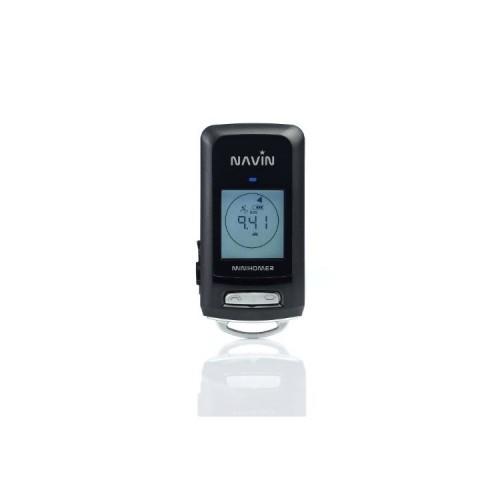
The device provides a number of options, one of which I have so far only a few have used. An intuitive operation is by no means given, there are just two buttons ... But the most important functions can be memorized after a while even without manual.
These are in my opinion:
Start / Stop 1 lap recording
2. POI (Point Of Interest) set.
3. "cue" add / View
Any number of POI are set that are not to be confused with the "watch points"! Of which there are a maximum of 5, which are represented by different symbols (house, car, knife / fork, flag, heart) to distinguish them from each other. So for example, when leaving the hotel one sets the cue "House". When the later indicating you can see distance and direction to the point and can see him again.
You can about the software - what was important for me - Photos with GPS data provided. As a reference to the time of photo and recorded waypoints taken. The tolerance can be set myself and it's not that (as I have read elsewhere), that every second waypoints must be set in order afterwards to be able to tag photos. For tagging the temporally closest point is taken within tolerance.
You can also set, after how many meters or seconds a new waypoint will be, but this is only possible via the software.
The altitude record ends at 10000 meters (altitude was about 12,000 meters) and distances (eg a "cue") are on the device only up to 1999km displayed. But I find that rather unimportant.
To analyze the lap recording you also need a notebook with the associated software NTRIP. And here I see the greatest shortages and reason for two star deduction:
The software does its job, but the usability leaves much to be desired. In a few settings opens up not at all, what they do exactly. The user interface is inflexible (I say only responsive design ...) and to changes in the route display often skips the card, etc.
I will not go into detail here, there are some small things that go me when operating properly on my nerves.
The data can be in different formats (eg CSV, KML) file. A waypoint in a .csv looks like this:
1384,3,2012 / 07 / 12,10-43-24.00,2012 / 07 / 12,19-43-24.00,35.731703, N, 139.710384, E, 99.8,3.9
What does this mean exactly what value, but one has to think for themselves:
[0] 1 consecutive number
[1] 1 I suspect it is the section of the route (routes can be divided into sections, automatically or manually)
[2] 03.31.2012 Date and
[3] 11-31-59.00 time GMT 0 without DST
[4] 03.31.2012 Date and
[5] 13-31-59.00 time Local time: GMT is determined using the current program settings during import of data
[6] 52.531271 long
[7] N Northern / Southern Hemisphere
[8] lat 13.348010
[9] E East / Western Hemisphere
[10] 32.1 Height (m)
[11] 0.0 km / h
POI are exported separately, there lacks height and km / h details. The POI are also in the normal export include, but not marked, so just as a normal waypoint.
On a positive turn of customer support. I got a request by mail directly from the Managing Director (according to signature anyway) answered and you seem really strives to respond to feedback and improve the product (software updates).


![LogiLink® PCI sound card with Dolby 5.1 6-channel [PC0027B] (Electronics)](https://img.tgreer.com/thumb/85x85/d/74/d7445cee1ec62193.jpg)