
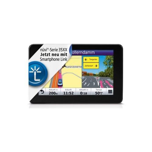
The display is very easy to read even in direct sunlight. Control of the Navis with fingers goes smoothly and very precisely. By contrast, the attachment to the windshield of course so its pitfalls, since transfer the vibrations of the windscreen on the whole Navi. Of course, these problems knows not the Festeinbaunavi.
The calculated routes were previously extremely precise and the "pushing" of interim targets, by using voice commands also managed without any major problems. To issue voice commands to a muting the radio has proved and the indicators should not just also before him tickers (Navi sitting with me right above the flasher relay).
The route options "Shortest" or "Fastest" find an immediate route called comes very close. Only the ecoRoute not led here to a usable target because in my vehicle consumption outside urban areas is significantly higher than in the village. So I'll take only sent directly to the motorway times half an hour through the city center, which is not particularly useful. The maps used by Garmin comes from Navteq and is in my eyes a bit worse than the Tele Atlas maps as they used my permanent installation. The one or other side-by-side road is missing but then ever.
The TMC-Pro works much better than the standard TMC my fixed installation, since it also supplies the precise navigation much faster and obviously with storage data. In direct comparison, I like it also better that the Navi not automatically sends me down from the original route, but once pointed out that a faster alternative route is available. Here then also the expected time savings will appear so that you can now decide whether you would rather not continue along the old route.
Use as handsfree worked for me. Even at higher speeds I could clearly understand my opponent. Should you, however, even have trouble understanding his phone partner, it is somewhat problematic, because the volume can be changed only in the settings of the main menu. Here is hoped the Garmin follows my suggestion and during the conversation allows direct volume control in the map view.
The other "apps" such as unit conversion, image viewer, etc. are partly faulty or poorly thought out, but hey it's a Navi!
Conclusion: Good route guidance, chic design, cards can be combined with OpenStreetMap, easy integration of the POIs POIbase or by Navifriends.
A few general notes nor the end. For map updates a good broadband connection to the Internet is an absolute requirement. You should also connect to the map update that Navi definitely to a USB 2.0 or 3.0 port, otherwise you can update already take a few hours.


![8 Watt [GREENLINE®] LED spotlight 12V MR16 / GU5.3 warm white](https://img.tgreer.com/thumb/85x85/e/9e/e9ed68b46d13c818e958655579e5a3be.jpg)


![Destiny - Standard Edition - [PlayStation 4] (Video Game)](https://img.tgreer.com/thumb/85x85/8/85/885b488afa15173f9f8ff36e734772a4.jpg)
![Project CARS - [Xbox One] (Video Game)](https://img.tgreer.com/thumb/85x85/7/c0/7c0d13927791ad1e.jpg)


![Split / Second: Velocity - [PlayStation 3] (Video Game)](https://img.tgreer.com/thumb/85x85/3/37/337898c031f2aff1.jpg)


