
Now after almost a year I write the review. Even though I have only given 3 stars, I would probably buy it again, not because the flaws are negligible, but because I really need some outdoor functions, and because for exotic destinations just has no alternative to the market leader. In the car I'm going to use it only outside of Europe and on the bike remains my additional bracket for a proper Strassennavi.
The Review in detail:
General:
+/- Solid, waterproof case, the heavy weight creates a sense of quality, but I have a suspicion there are simply heavy parts have been fitted to generate this feeling .. the disadvantage that falls from greater height despite reinforcement problematic than with a 100g portion, and the disadvantage that you have to carry around just back a few 100 g with it.
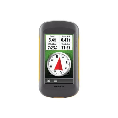
+ Great and really easy to read display, compared with normal car Navis convinced the technology in all lighting conditions, in direct sunlight even in passive mode. However: anyway if no benefit is in color, one could
also equal use a Paperwhite display in direct sunlight all LED display have their weaknesses.
- But low resolution .. here sees the big screen again from old against current TomTom, Navigon, etc .. While it is ergonomic, if you only get information display, which can be read without reading glasses or from 3 meters .. if you know better, it's just the Stone Age.
+/- Position sensor: the case of large shocks come as ever all mixed up and the image is upside down, so switch off better on bike and motorcycle.
+ Battery concept ... The battery lasts 8 hours without any problems a hike and still shows remaining time, battery 4 NiMd bring similar maturities .. you have the reserve as this, which is a safety factor in proper outdoor tours, which I could not live without. Despite setting which type of battery is used, but annoying error message Battery nearly empty, although the display still shows 70% and the unit even after many hours of running.
- An unintelligible Minus: no base for a hand strap or a shoulder strap, except for a narrow slot .. and if you as threading a ribbon, then adjusts that no longer falls into the bracket.
Features:
++ Compass, altimeter, sunset table saves Extra tables, equipment really well thought out and easy to use.
++ More functions, I have not gesteste for use at sea (Man Overboard), on land and in the air. From Geochaching I have only read in wonder what you can do to be conducted except for certain co-ordinates.
- Software .. well simple and intuitive to use, I can not call it, it gives me the impression that you as the whole history of Garmin drags, many apparently still comes from the generation of 10 years ago (I still have a eMap ), then spiced up with looking for apps optics, but in the end a lot of functions are scattered about the options in the Map mode, or the General Setup, or the profile properties in any case it costs a lot of time and nerves, until halfway everything figured out and if you the fun ctio has not sale 3 weeks of searching we go again. And many will not, though sooo simple: why, for example, can I only edit one of the two display panels in Strassennagigations dashboard NÜVI: Distance to least, Time to least, Altitude, etc .. and the right pane always shows the speed, an indication which you already have ?? usually by car or motorcycle
Cards / licensing policy
- Memory usage: A big double minus .. no question that I concede Garmin to want to earn money on the card, but you do not have to limit as it is the case the function and usability of the storage media. Why can not I place despite genügens spoke only store a map (I can save more, but there is only one acceptable filenames, but I have to rename remove the battery, the card into the PC ..). After all, it is I managed to install the device open source maps, and adapt to the memory card the NT bought Strassennagivation and depending on profile (cyclists, pedestrians) a preselection.
- Updates: I am talking from the Strassennagivation, their quality still I discuss later, the top card I have because of exorbitant price 200 euros and freely available OSM alternatives pulled no closer into consideration, especially since I'm traveling around the world, and 200 Euro is just next to it only for Germany and without updates. NT cards are cheaper on first glance, only so much we cost a Medion Navi, for the Montana can be next to Blitzer no, no traffic information, there is no guarantee to get new cards, or even inexpensive updates .. nothing !! ... And then there are 3 versions: Free, DVD, and smart card. The devil is in the details: the DVD is rarely issued, nor for all versions, so you have to sensibly the least !! but mitkaufen available update the same, then you have the map also available on the PC, in base camp. In the other versions, the cards in Base Camp, even when the connected device is not available !! I plan a route with another, perhaps newer cards, and the unit the planned ring road or the new roundabout at the real navigation knows then not .. Great !!
Do I buy the download, I get the latest version, but has to buy the memory card, and certify for a device are the purchased SD card only is reasonably up to date, but also to replace your device still usable.
In Navigon to purchase equipment for 110 euros, with free update for commissioning and for 20 euros extra I get for 2 years every 3 months upgrade (Navigon incidentally belongs to the Garmin Group)
Nagivationsfunktion:
+ Hiking, biking with OSM maps ... Stimmig to use, whether entered manually with routes from the Web, or with routing to nahegeliegenen waypoints from the database, or. The reception is significantly better than when AutoNavi, even in dense forests and narrow canyons rarely aquiring Satellites
- You can indeed nice set the profile indivduell and save different versions, but everything will be invalid if you take just edit the map settings and accidentally Restore Defaults comes. IMPOSSIBLE: the function is reset all the fat in the Map menu and without reconfirmation !! no Do you really want / to confirm .. blah blah ..
- Strassennagivation (minus or fat minus was the idea) .. The graphics are Stone Age, so what you had in the car in front of 3 generations, so 6-8 years ago! Although the cards are the same, it sucks the slow speed .. often appears after turning even seconds, turn right and after
Deviation from the route takes the recalculation perceived eternities when current device is used. The / only in the Garmin car mount / Speech can save you need: over the display is not the voice say, and this is precious little and often misleading, the map as a graphic is at least an orientation with which to get to the destination , Missing extras like lane guidance I need not mention, as well as the 2 Stepped Preview: 50m in the roundabout at the 3rd exit and then sharp right .. very much missed. To the text, spoken or read to leave inevitably leads to errors.
- Input targets: so uncomfortable as it gets, but very bad I find the lack of ability to search for a POI on the route or at the destination, or at a certain place .. No: all POIs are in the database, but searchable only near !!!
- Influence of routes: No. There is a choice not .. Garmin anticipates and expects, and then one must follow .. and avoiding (Avoidiance Setup) seem to be ignored in many cases always go .. (bicycle routes on the road , of the function in Navigon: prefer beautiful streets, one can only dream)


![Microsoft Office Home and Student 2013 - 1PC (Product Key) [Download] (Software Download)](https://img.tgreer.com/thumb/85x85/1/f4/1f49596ee339f4aa3c52f4cbcd2afb70.jpg)


