After the first experiences with the previous operation was soon no longer an issue, although I still find new, useful features. On the internet I have loaded me free map of OMS Computerteddy. I finally ended up at the routable map of Germany and the map of Europe (not routable). Both fit together on 2GB Micro-SD card, you just have to rename the card is not used. If you place the device in mass storage mode, this is no problem. The cards themselves should describe directly via card reader from the PC, then it goes very fast. Then, the map of Europe with approximately 650 MB is charged at lightning speed.
The OSM maps are topo map of highest current quality, in very many trails are listed. For example, a new roundabout, still under construction but already drawn.
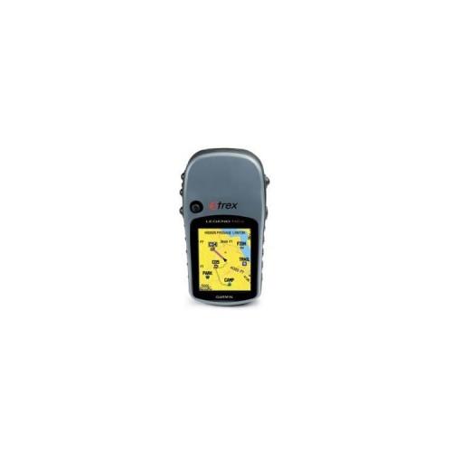
Together with the routable map, there were not previously unimagined possibilities as Navi in the car. So in a short time a car holder with suction mount and a 12V to USB adapter was obtained. With the supplied USB cable to the Legend HCx via the adapter will be powered from the car cigarette lighter power. With backlight to continuous operation at full brightness, it now shows me the way in the car over many hundreds of kilometers in the car routing operating very reliably in eg (Southern Germany - Ruhrgebiet was easily). However, no announcement, the proximity alert Abbie racks and display with directional arrows works very well and clearly. Even automatic recalculation when leaving the track or not followed when turning in it and very quickly.
Changed to autorouting for pedestrians he gets along well while hiking. However here without turn by turn, but with a very good map display in the direction of walking. For geocachers it is absolt Super. Enter Geocache coordinates, autorouting turn and already the way through the smallest paths is displayed. One only has to go off and comes on. Whoever wants to can, of course, straight run conservatively by a straight line across the field.
Compared with the eTrex H side by side both devices are as sensitive and show absolutely identical coordinates.
Why only 4 points? The manual and the built-in card can be forgotten. Luckily, there are forums on the Internet where you can read all the free and reloading, which is not in the manual or on the map on it. And that's a lot. Since you bought a super unit and receives no instructions from the manufacturer, what is possible. Too Bad. This is also reflected here down in the reviews. Since grumbling about missing features that actually drinstecken the device, only the treasures have not been lifted. Since one has no choice but to try itself. I'm still not end up with the to learn, although I now intensively use the thing for 6 weeks. Every day some new highlights to which I would not recognize. It grows with the tasks and Legend HCx is becoming legendary.
My next projects: use as a bicycle-Navi and complement as OpenStreetMaps tracker missing routes in the map ... that helps me and others.
Conclusion: an excellent device that I can only recommend.
Now, almost a year later: The rubber coating has dissolved. The underlying adhesive is softened and swells out at the edges. The Internet is full of them. A series mistake that Garmin has not come to grips with for years. I have resorted to self-help. Rubber sleeve down, wiped glue residue and newly glued with double-sided carpet tape, and if that should solve again, rebonding with superglue with a few drops. On the keys you have to cut anything. That still works as before, slightly more pressuring you. The experiment with Pattex has not adhered to the rubber. Was a murder mess because everything sticks, only the rubber is not ... But now is rest. Who knows how long. The device works but still fine.